
3·
17 days agoSo… like running a blender in reverse? 😁
So… like running a blender in reverse? 😁
I’m down to reject bigots being bigots. But even a broken clock can be right twice a day.

Holy hell! This was the most succinct, concise, and “yeah, your high school history textbooks whitewashed all this shit” summary of the modern Conservative political machine. It’s like Robert Evans, Matt Taibbi, Jake Hanrahan, and Kurt Andersen had a love child that came out as a summary text.
If anyone got to my comment here, but only skimmed parent comment, please do yourself a favor and bask in that bit.

For all of us Aeropress junkies, here’s a deep rabbit hole: https://aeroprecipe.com/. I hope y’all have as much fun as I did playing around with the recipes and results options.
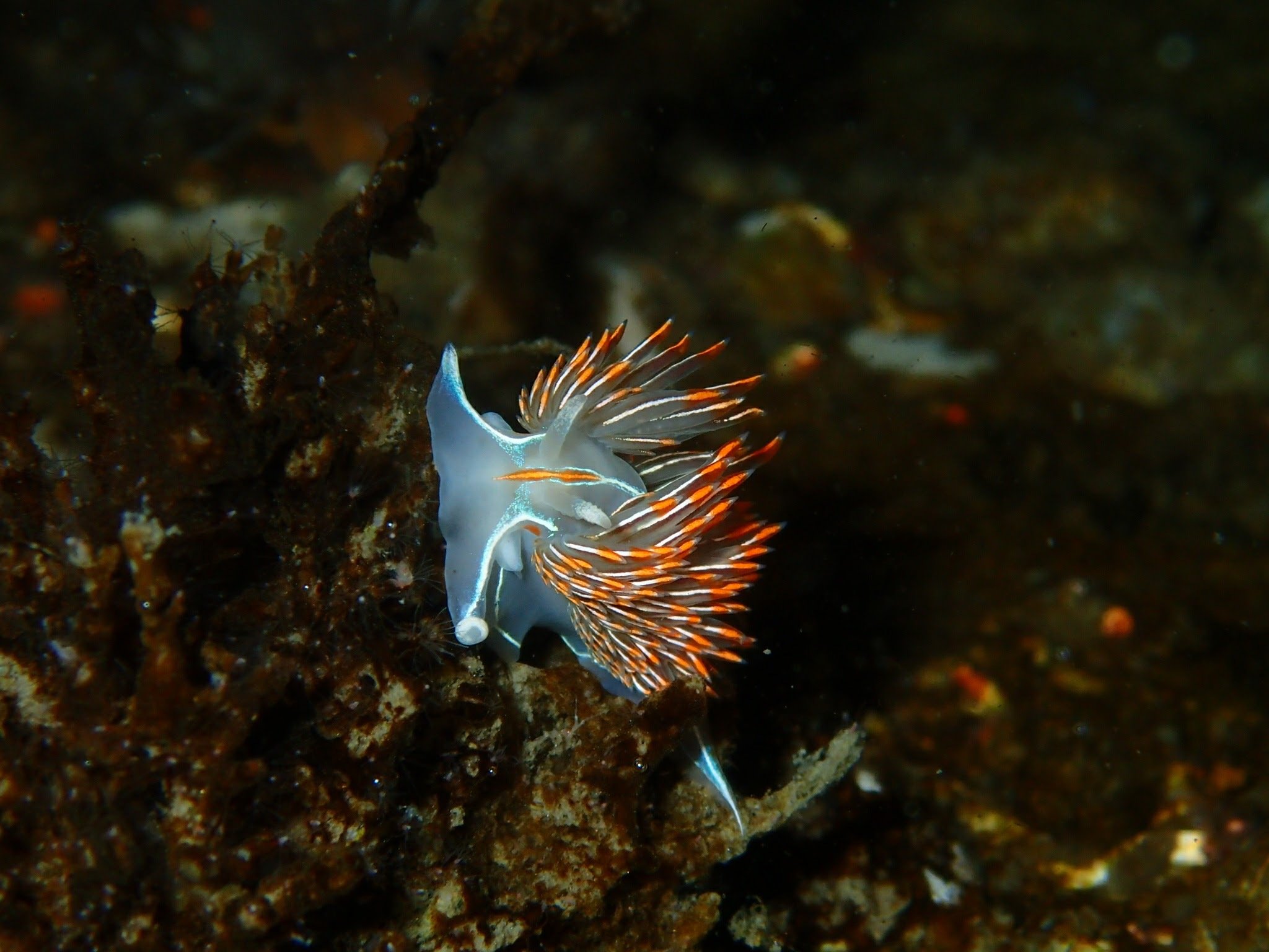
Monterey sea lemon, Hood Canal WA USA

Ask and ye shall receive! Giant nudibranch, Sinclair Inlet, Bremerton WA USA

These nudis are very common on the docks where I moor my boat. This picture has the saturation punched up, but still fails to convey just how trippy they, and most other nudibranchs, look in person. The iridescence in the rhinophores and cerata is something that can be tricky to capture with imaging. Here is a different angle of the same species.

Oh, right! I forgot about all of the LIDAR-equipped planes in maritime communities! Those are way more economical to fly than any sUAS. /s in case that wasn’t obvious.
In case you, or anyone else, were vaguely interested in learning:
-kelp extent mapping needs to be done in repeatable fashion, specifically at low tide; we can put up an sUAS any time
-the communities most in need of monitoring absolutely cannot afford to send planes up monthly
-many of the kelp beds in the PacNW are in restricted airspace; it is much easier to get an FAA clearance to perform low-altitude surveys using sUAS
-that restricted airspace I mentioned? Some of these kelp beds are on approach paths for the airspace. Even if a plane were the preferred choice for surveying, the planes are unable to fly in the pattern we need
-(drifting a touch off your point of LIDAR-equipped planes) satellite imagery with the required resolution is prohibitively expensive
-most construction projects wouldn’t use a plane for tasks such as volumetric or area analysis
Consumer drones are quickly becoming the preferred, economical means for kelp health analysis, especially for communities that can’t afford planes or purchasing satellite imagery.
This “lonely adult” uses drones for aerial mapping and survey. This Summer’s huge project is a workflow I developed to map the extent of PacNW bull kelp forests in order to provide year-over-year health metrics. Using sUAS for this is way more automated, economical, repeatable, and granular than using airplanes and satellites, therefore within reach of those communities monitoring kelp health.
DJI hits the sweet spot of capabilities, compatibility, and cost. Skydio (go USA!) has abandoned the consumer/enthusiast market that built their business. And even before they turned their back on the consumer market, Skydio couldn’t come close to DJI’s hardware. Additionally, Skydio, in true capitalist fashion, locked capabilities away behind software licenses, capabilities that are already built into the drone.
It’s important for countries to have domestic drone manufacturing in the current conditions. But the USA’s actions here smack of protecting companies that just can’t hang.
Stainless steel that gets coated is no longer stainless steel. Stainless steel requires exposure to sufficient oxygen in order to maintain the protective oxide layer.
These are rudder bolts from the same gudgeon on my sailboat. The black stuff is anoxic corrosion.


It’s interesting how most invasive species seem to be not good eating for humans.
Fully agreed! However, invasive lionfish buck this trend in tasty, tasty fashion. I daresay it’s the best tasting fish, bar none. I liken it to albacore sashimi with Kerrygold butter put together, but even better.

Squid, my deepest empathy for your medical journey ain’t worth shit, but you have my empathy regardless. Without boring anyone with unrelated detail: I’ve been there. Kudos for your self-advocacy.
So I wrote a very long and angry email to the patient advocate
This right here, everyone. This person’s entire role is to cut through red tape. In my experience, the patient advocate is the Winston Wolf of their hospital departments.
As an aside, Flying Squid, I always appreciate your contributions to the Lemmy community, even when I disagree. Thank you for being you.

Instructions unclear. Used boulder. No more sound comes out.
Yep, I’m an inveterate purger. I have tried to control the purging with a policy of hanging onto things such as power tools for one year past its last use. And almost invariably, about two weeks after I finally got rid of the thing, I need it again.
In my case, I have a very small living space, so hanging onto things just means they’re in my way. But I was like this even when I had a large house.
Whole, modern, domesticated fruits do contain quite a bit of sugar, but that sugar is locked up in fiber. There are lots of anti-sugar crusaders that consider whole fruit to be a “gimme.” Gary Taubes (Good Calories, Bad Calories) and Robert Lustig (Sugar: the Bitter Truth) are two that leap to mind.

If the hardware is still great, how about installing LineageOS? Here’s the direct link to LineageOS for the Pixel 4a: https://wiki.lineageos.org/devices/sunfish/. I’ve been using LineageOS on all the old devices which are supported, mostly OnePlus and Nexus devices. Lightweight, and does everything I need.


Having seen firsthand what happens when someone unknowingly enters a hypoxic enclosed space, I think the difference is foreknowledge. Thrashing sounds like acidosis from holding one’s breath. I was helping an acquaintance work on his old steel boat. There was a watertight compartment. The risk of steel-enclosed spaces is that rusty steel in an enclosed space can consume all of the oxygen, leaving only nitrogen rich air.
He opened the hatch and, before I could stop him, he just strode on in like it was nothing. He was unconscious before I could get to him, maybe ten seconds. Fortunately, he was near enough to the hatch that I could just reach in and grab him, rather than trying to find an air tank and regulator, and then put it on.
He recovered just fine, but had a terrible headache. He didn’t remember anything about it. He didn’t thrash. There was no drama. He walked in and fell unconscious. Lucky for him it was a small space, so the bulkheads kept him from doing a full header into the steel deck.